Parks Canada has completed the most comprehensive survey to date of the HMS Investigator wreck in Mercy Bay off Banks Island and is assembling a detailed 3D model of the site to support further research into mid-19th-century Arctic exploration and local Indigenous connections to the vessel.
Historic wreck, modern technology
The Investigator was abandoned in Mercy Bay in 1853 after being held fast in sea ice for three years. While its story is less widely known than the Franklin expedition, the Investigator's voyage and its aftermath are pivotal to the history of European Arctic navigation — including the fact that members of its crew were among the first Europeans to traverse parts of the Northwest Passage.
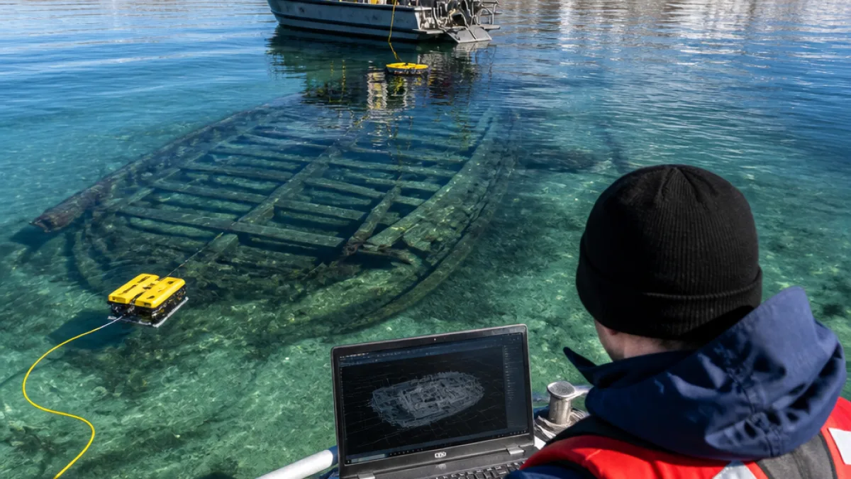
This year's field work — described by Parks Canada as the most thorough assessment since the site’s discovery in 2010 — combined underwater archaeology and remote-sensing tools to capture the wreck and surrounding seabed. The resulting data are being used to compile a high-resolution 3D model of the site.
Why a 3D model matters
Officials say the digital reconstruction will function as a preservation and research tool. The model allows archaeologists and Indigenous partners to examine the wreck virtually, monitor deterioration over time and answer specific research questions without repeated intrusive visits to the site.
- Document changes to the wreck and seabed without physical disturbance.
- Support research into the daily lives and material culture of crew members aboard Investigator.
- Provide a platform for collaboration with Inuvialuit knowledge-keepers on the site’s history and meaning.
Ryan Harris, a senior archaeologist with Parks Canada involved in the project, described the Investigator’s story as a dramatic episode of Arctic exploration marked by hardship and survival.
“The 1850 to 1853 voyage of HMS Investigator is absolutely enthralling,” Ryan Harris said, calling it “a really harrowing tale of Arctic exploration — one that's marked by ambition, discovery, suffering and privation, and, ultimately, of improbable rescue in the face of almost certain death.”
Well-preserved remains and community connections
Parks Canada has characterised the wreck as a "remarkably well preserved underwater museum," with structural timbers and artefacts sitting on the seabed in Mercy Bay for more than 170 years. Because the site lies in waters adjacent to Inuvialuit communities, researchers are emphasising joint stewardship and the importance of Indigenous perspectives in interpreting the wreck.
Those perspectives are essential to understanding not just the European narrative of exploration but also the ways Inuvialuit people encountered, used or understood the Investigator and its material traces after the ship was abandoned.
Context and timeline
The basic timeline of the Investigator and recent work can be summarised as follows:
| Year | Event |
|---|---|
| 1850–1853 | Investigator becomes trapped and later abandoned in Mercy Bay. |
| 2010 | Wreck site discovered and preliminary documentation undertaken. |
| 2026 | Parks Canada conducts most thorough assessment to date and begins building 3D model. |
Research goals and public benefit
Parks Canada's stated objectives for the modelling and survey work include building a robust archaeological record, improving conservation planning and expanding public access to the site through virtual interpretation. A 3D model can be used in educational programming, digital exhibits and to inform future management decisions for the wreck, which sits in a remote Arctic location where repeated physical visits are costly and environmentally sensitive.
For historians and archaeologists, the model will help address questions about ship construction, the distribution of artefacts around the hull and how ice and current conditions have affected the wreck over time. For Inuvialuit communities, the work opens possibilities for co-produced interpretation and for incorporating local oral histories and place-based knowledge into formal records.
Practical implications for the North
The project demonstrates how contemporary technologies — photogrammetry, sonar mapping and remote sensing — are being applied to northern cultural heritage. It also raises wider questions about protecting underwater heritage as shipping, resource activity and climate-driven changes to Arctic sea ice continue to reshape the region.
As Parks Canada finalises the 3D model and analysis, the virtual record should allow researchers and communities to study the Investigator in detail while limiting further disturbance to the physical site in Mercy Bay.
This combination of high-tech documentation and local partnership sets a precedent for how Arctic wrecks and other submerged cultural resources might be stewarded in the years ahead.